
Bangor University Notice to Mariners – October 2025
Conwy Bay/Constable Bank fish trawl and sediment sampling surveys
Mariners are advised that Bangor University’s School of Ocean Sciences are scheduled to undertake fish trawl surveys in the Conwy Bay and north Constable Bank areas between 7th-10th October and 13th-20th October inclusive. The fishing surveys will consist of a maximum of two 1-hour long trawls per day. A sediment grab sampling survey will also be conducted in the Red Wharf Bay area between 13th-20th October.
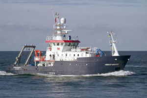
The work will be undertaken by Bangor University’s survey vessel ‘Prince Madog’, call sign ZNLJ5, monitoring VHF channel 77.
Please coordinate with the vessel during this period and note that the sampling locations may vary slightly depending on weather and other factors.
Contacts:
Scientific Lead (vessel mobile): 07860342451
School of Ocean Sciences, Askew Street, Menai Bridge, LL59 5AB
Dr Ian McCarthy ([email protected]): 01248 382862
Dr Michael Roberts ([email protected]): 01248 383966
Vessel specifications and contact details
| Contact Details | |
|---|---|
| Vessel name | Prince Madog |
| Call Sign | ZNLJ5 |
| IMO | 9229611 |
| MMSI | 235234000 |
| Vessel Contact | [email protected] |
| Vessel Specifications | |
|---|---|
| Length | 34.9m |
| Beam | 8.5m |
| Draft | 3.7m |
Trawl Surveys
To research local demersal fish populations as part of an ongoing 50-year study, 1-hour rockhopper otter trawl surveys will be undertaken in the boxed areas indicated on the chart below. The surveys will be conducted between 7th-10th October and 13th-20th October inclusive. The exact locations (start and end points) for the trawls will be dependent on factors associated with weather, tide and time available. A maximum of two 1-hour trawls will be conducted each day as per dispensation from Welsh Government (DISP_2024_024)
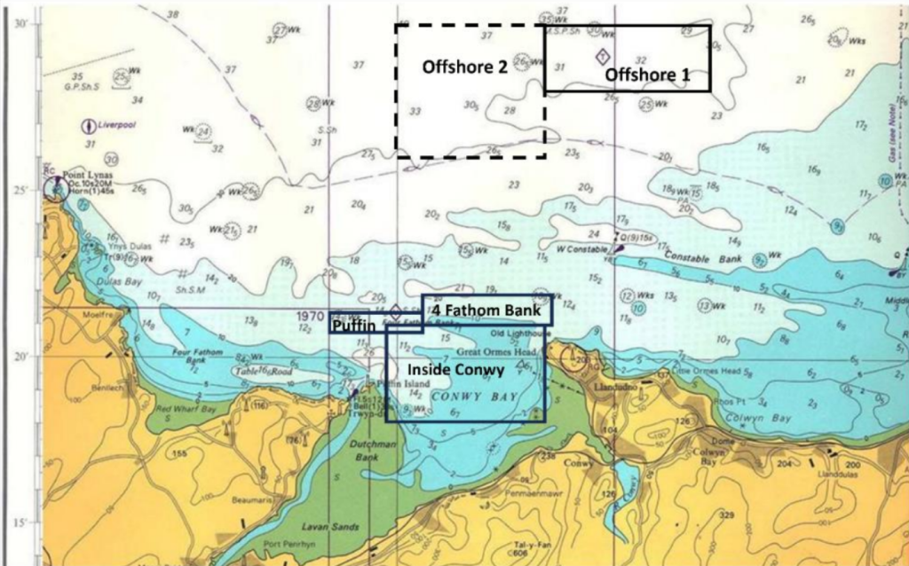
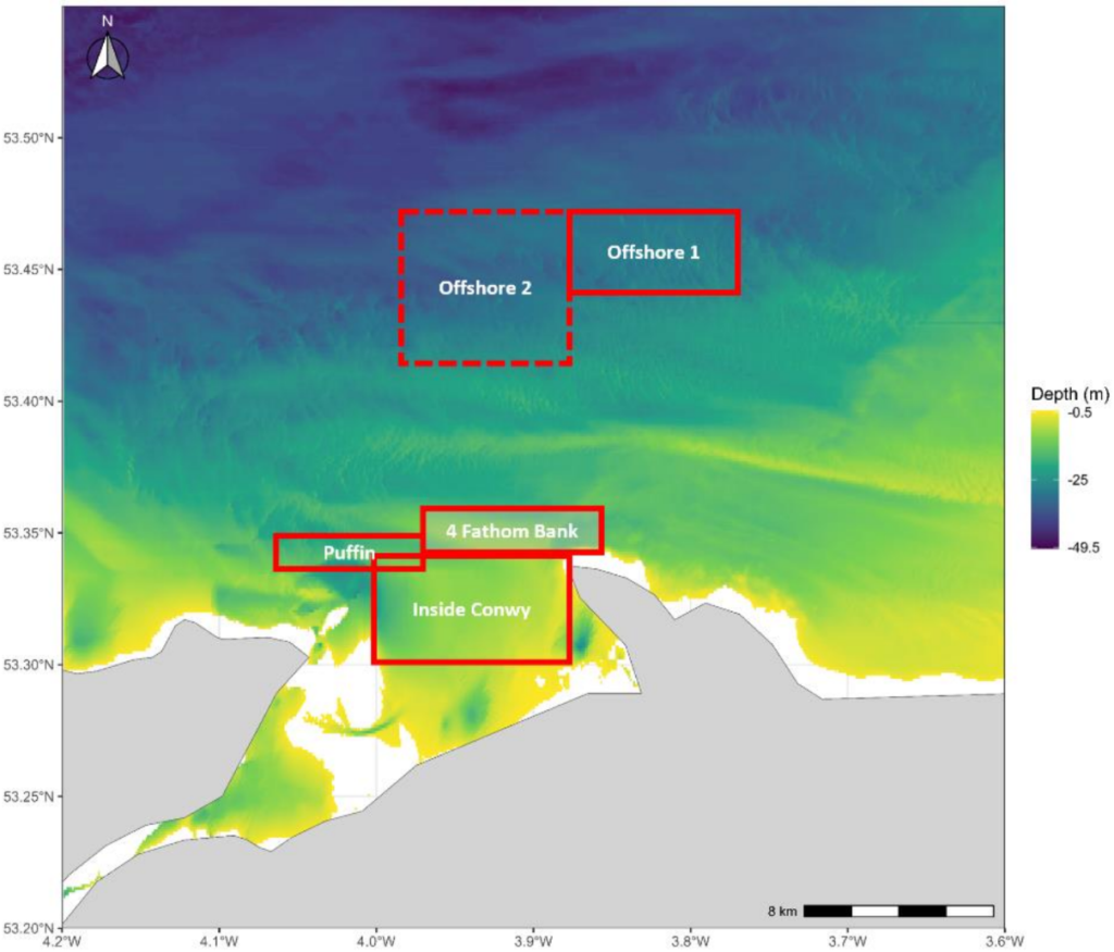
Areas to be Surveyed
Offshore 1 – within an area bounded by 53 28’ and 53 30’ N and 3 40’ and 3 52.5’ W
Offshore 2 – within an area bounded by 53 28’ and 53 30’ N and 3 40’ and 4 00.0’ W
4 Fathom Bank – within an area bounded by 53 21.2’ and 53 21.6’ N and 3 52.4’ and 3 58.5’ W
Puffin – within an area bounded by 53 58.5’ and 53 21.2’ N and 3 40’ and 4 03.5’ W
Inside Conwy – within an area bounded by 53 18.1’ and 53 21.4’ N and 3 52.8’ and 4 00.5’ W
Red Wharf Bay Sediment Survey
A survey of the benthic infaunal community (animals living in the surface sediment) in Red Wharf Bay will be conducted between 13th and 20th October. Triplicate sediment samples will be collected using a Day grab from each of 15 sampling sites located along three depth profiles as shown in the figure below (see Table for planned co-ordinates)
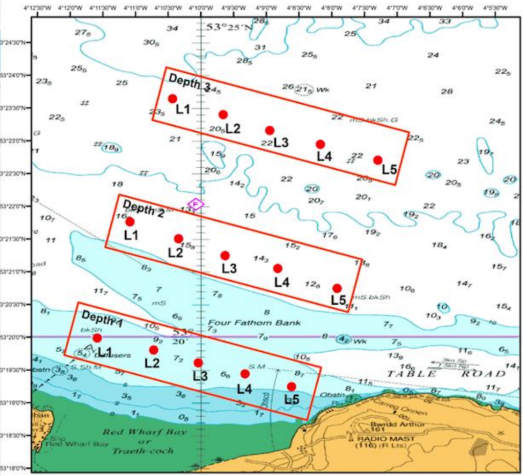
At each sampling site, three grab samples will be taken as close together as possible. Each grab sample will collect sediment from 0.1m2 of seabed.
| Depth | Location | Long DD | Lat DD |
|---|---|---|---|
| D1 | D1L1 | -4.19306 | 53.33311 |
| D1 | D1L2 | -4.17866 | 53.33008 |
| D1 | D1L3 | -4.16729 | 53.32679 |
| D1 | D1L4 | -4.15541 | 53.32401 |
| D1 | D1L5 | -4.14353 | 53.32073 |
| D2 | D2L1 | -4.18472 | 53.36268 |
| D2 | D2L2 | -4.17234 | 53.35838 |
| D2 | D2L3 | -4.16046 | 53.35409 |
| D2 | D2L4 | -4.14707 | 53.3508 |
| D2 | D2L5 | -4.13191 | 53.34575 |
| D3 | D3L1 | -4.17386 | 53.39401 |
| D3 | D3L2 | -4.16097 | 53.38997 |
| D3 | D3L3 | -4.14909 | 53.38593 |
| D3 | D3L4 | -4.1362 | 53.38239 |
| D3 | D3L5 | -4.12155 | 53.37834 |
Good Afternoon.
My name is Tom Edge – I am the RWYC Safety Officer for the Castle to Castle ( Beaumaris to Caernarfon) rowing race staring at 1200 on the 11 October 2025, and will be passing Menai Bridge about 1300 ish. We anticipate 20 plus, Celtic five person rowing boats.
I note the two survey locations and dates which do not create any issues for our event, however, please can you confirm the movements /location of the Prince Madoc on the 11 October.
I will use the information for the safety briefing for the Coxes.
Kind Regards
Tom Edge 07831 805742
Hi Tom, many thanks for getting in touch about this, but the NWCC only collates and posts NTMs from around the local area – we aren’t responsible for the NTMs themselves.
So I suggest you get in touch with Bangor University directly with your queries, the contact details are in the first section of the NTM.
Best wishes,
Austin.